Translate

Tuesday, October 1, 2019

East-West New Jersey Dividing Line Flag


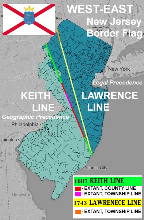
The division between West and East New Jersey is shrouded with an air of fuzzy logic.  There were several surveys which tried to keep New Jersey divided but three of the most important lines of division were the Quintipartite Deed line of 1676, Keith Line of 1687, and Lawrence Line survey of 1743.

The only line partially visible on most maps of New Jersey is the Keith Line of 1687, which was made on the pre-centennial of the US Constitution.  The Keith Line is distinctly visible where Ocean & Monmouth Counties make contact with Burlington & the lower neck of Mercer Counties.   The Kieth Line is also visible where Somerset makes a line with Hunterdon County and the upper crown of Mercer County.


Nonetheless, this flag marks the division between West and East New Jerseys.  The red X (or saltire) is taken from the flag of Original Jersey in the English Channel, as is the crown.  But instead of three English Lions, three plows of American Jersey are visible.

This flag can be flown anywhere across the dividing lines of the 1687 Keith Line and 1743 Lawrence Line.  The Keith Line has historical and modern geographic precedence over the 1743 Lawrence Line.  And not to mention providential precedence, since the Keith Line is dated 100 years before New Jersey became the third state in the union on December 18, 1787.

Flag of Original Jersey in the UK
On the other hand the Lawrence Line has legal precedence since the New Jersey Supreme Court defined it as the legal settlement for issues back in 1855.   So no matter, this debate of the dividing line between East and West Jersey gives this flag a large swath of land to be flown over.

For ultimate rivalry championships between East & West Jersey, those places like Princeton can choose sides at their discretion.

All the places south of Egg Harbor are on the West Jersey team, which includes the Philadelphia area, Atlantic City, Ocean City, and Cape May.  Likewise all the part of Jersey to touch the Delaware River is on West Jersey's team.  Like any West Coast state, you can only catch a full ocean sunset from West Jersey at the tip of Cape May—the top of the Pharaoh's Crown.  Finally, of ultimate claim to USA fame game, Monopoly, is a West Jersey original. 

http://www.njfounders.org/history/1676-division-new-jersey-east-west-boundary

Heroes from East New Jersey
Costello of Abbot & Coastello, Buzz Aldrin
Judy Blume, Bon Jovi, Danny Devito, Ed Harris, Ray Liotta, Jack Nicholson
Shaq, Joe Pesci, John Travolta 
"Tony Soprano" "Marvel Boy" "Paul Blart" - Mall Cop

Heroes From West New Jersey:
"Aqua Teen Hunger Force"- Carl, Meatwad, Master Shake, Frylock
King Kong Bundy, Kelly Ripa, Kurt Loder - Classic MTV, Dave Thomas of the Wendy's fast food
Dennis Rodman, "Jay & Silent Bob" 
 West or East????
"Indian Jones"
"Harold & Kumar"


East New Jersey Flag


The East Jersey flag has the original seal in the orange upper-fly ward half.  The Orange colour is derived from the Goddess Liberty of the modern seal of New Jersey.  She is wearing an orange blouse and holds a Phryigan cap on her staff.  Coincidentally East New Jersey is home to the State of Liberty.  The buff (yellow-tan) stripe is also taken from New Jersey's modern flag.

The on the outer ring of East New Jersey it reads, "The seal of the province of East Iersy in America."  Sometimes Js where written with Is, because of this old rule and that old rule.   In the inner ring there are two messages.  The upper message in red reads, "Righteovsness Exalteth a Nation."  Again another funky alt switch of writing a U as a V has taken place.  The legend is that the letter U is a cursed letter or something like that, another ancient this and that rule lost to the sands of time.  Underneath in yellow is written, " Its God giveth increase."  Along the side of the shield of arms is a fancy S and mirror S on both sides.  The shield is divided; the upper part is red and the lower is white.  The upper area has an arm of divine origin holding a balance-scale; since the arm is coming out of a cloud, this represents a connection to Divine Will.  In the lower white area is a sheaf of wheat with two pealed ears of
corn.

Coincidentally the Seal of West New Jersey also has balance-scale.  New Jersey's Hudson Valley is squarely a part of East New Jersey as is Sandy Hook. 


https://www.nj.com/news/2015/06/how_a_man_named_keith_took_a_long_walk_and_defined.html

West New Jersey Flag


The West New Jersey flag conserves the original seal of West Jersey in the lower hoist half.   The lower triangular red field is based upon the blouse of Ceres from the official state flag of New Jersey.  The Goddess Ceres is holding a cornucopia full of produce.  The seal was used in an official capacity during the reigns of King Charles II,  King William III & Mary II, and Queen Anne.   Around the ring it is written "Proprietors...West New Jersey."   It features a united drawing-compass & balance-scale with a tree in the middle.  Ceres represents West New Jersey the best because, this side of the state has a higher agriculture output, and is where you can find the best 'Zesty Tomatoes' in all of the United States. 

West Jersey existed from 1674 until 1702, with Burlington as its capital.  The first settlements were by Sweden, which was later overrun by the Dutch in 1655.  But in 1664, the British had the final say in the colonial heritage of New Jersey.

There were several attempts to spell out the division between West New Jersey and East New Jersey, but survey that had deepest impact as it can still be seen on any map of New Jersey is the 1687 Kieth Line. This line is visible with the county line that divides Burlington, Ocean, Monmouth, and the lower chine of Mercer.  It is also visible with the county line that divides Hunterdon, Somerset and Mercers upper crown.   The other lines are not noticeable on a map of NJ, except for the Keith Line.  West New Jersey has the state capital of Trenton, which was also the federal seat during the Articles of Confederation

period for the Fall of 1784.  Also Cape May and Delaware River water front is solidly a part of West New Jersey. 


Saturday, September 28, 2019

The New Dela-Jersey Flag, where Delaware & New Jersey share a common land border


The New Dela-Jersey flag combines the flags of Delaware & New Jersey in a special way.  Basically an slightly impaled double diamond, or the 'Batman' device.  The blue part of Delaware has spilled in the diamond of New Jersey.  Other than that the coats of arms are the  same.

Delaware and South-Western New Jersey have common heritage as they where once apart of the New Sweden and later New Netherlands, before becoming an English Colony.  So their first Old World
Mother tongue of settlement was Swedish, then they had to switch to Dutch, and finally they settled on English.

There are two areas where Delaware soil makes contact with New Jersey.  The northern-upper portion is in Salem County, NJ that shares a land border with New Castle County Delaware.  On the local level it is Pennsville Township, NJ that borders Delaware.  It is about two square kilometers of land.

The main reason why Delaware shares a land border with New Jersey is because any new land in the Delaware river automatically becomes a part of Delaware.  Unlike New Jersey's border with Pennsylvania where the two states share the river to the middle.  Delaware bogarts the entire Delaware river.  So New Jersey's claim to the Delaware River stops at Pennsylvania's southeastern border by the Sunoco Marcus Hook Refinery.  This is sort of like opposite situation with New York and New Jersey.  Because any artificial land added to the State of Liberty or Ellis Island, shall belong to New Jersey.

The other 'Southern' connection point is next to the Hope Creek Nuclear Power Plant Station.  I tried to visit the area, and was greeted with a much less than friendly attitude.  Even though they have a visitors entrance, they don't want visitors—it's a Catch-22 situation.   They will basically give you a one finger Jersey Salute, if you try to visit.

So, the best way to visit New Deli-Jersey is from Fort Mott Park.  If you plan on visiting, the best option is to leave from the ferry Delaware City in Delaware. After you get your fill on the way awesome Fort Delaware , a ferry will go to Fort Mott.  From there you can reach New Deli-Jersey, but remember to watch the ferry schedules back to Delaware City.


The name of the northern point is New Dela-Jersey, the Southern point is known as New Deli-Jersey.  Or was it that, Delawarians call this area New Dela-Jersey and New Jersians call it New Deli-Jersey.  I guess we will never know. 


Friday, September 27, 2019

The Delaware River & Bay Authority Flag - 1962


In 1962 the state governments of New Jersey and Delaware had a baby.  This baby was the Delaware River & Bay Authority by compact between the states of Delaware & New Jersey.  Consequently a union flag of Delaware and New Jersey was one of the results.  This flag has the seals of both state but slightly modified.  New Jersey's shield is white instead of being blue.  The flag is a seal within a seal.  Or rather there are two seals that make up the larger seal.  Outside the seals of Delaware and New Jersey are the two key points of connection between these two states.  Above the the Delaware Memorial Bridge. Below the seals is the Cape May-Lewis Ferry.


New Jersey also has hybrid flags with Pennsylvania and New York.  It makes so much sense for New Jersey to be connected to Delaware as well, since their settlement mother tongues were Swedish, Finnish, and Dutch.  Only later did these two states learn English a bit later in their colonial life.


Thursday, September 26, 2019

Lanka Lion Flag for Sri Lanka


Since there is a Sri Tamil flag it only makes sense to have Sri Lanka version of the Tiger Tamil flag.  But this flag is known as the Lanka Lion flag.  Its purpose is to put the foot on the other hand.  At least it is educational, to make people think of the tragedy that befell on the of the most beautiful people upon the most beautiful islands of Earth.

Both Tamils and Lankas are wonderful people of amazing wisdom and beauty who are just coming out of a brutal civil war, that ended ten years ago.  Many civilians have suffered, and the despair is great.  But in the darkest night of the Isle of Tears is a ray of hope, for in the distant future, Sri Lanka will be an isle of love and joy for all humanity to appreciate.


Education & Hope is Our Weapon
අධ්‍යාපනය සහ අපේ ආයුධය බලාපොරොත්තු වන්න
கல்வி மற்றும் எங்கள் ஆயுதம் என்று நம்புகிறேன்
 

Sri Lanka Tamil Flag - The Sri Tamil Flag

Sri Tamil Flag 

Here is a hybrid Tamil-Sri Lanka flag.  It is also a flag for Sri Lanka-Tamil mixes who are have a Hindu and Buddhist ancestors.   If you ever see a report about this war, rarely will the press give details of the cultural orientiaions of the two sides.  The majority is a Buddhist India-like people group, while the Tamils are a Hindu-India peoples.  They have different languages and scripts, but both have ancient connections to India.

After 20 years of war, a fierce Warrior Buddhist leader in Sri Lanka decided unleash the full might of the Sri Lanka Buddhist Lions upon the Hindu Tamil Tigers.  Subsequently, the war finally ended 10 years ago, but the scars still run deep on both sides.

No doubt in the near future this isle will be known as paradise.  Tourists will flock here, and the beachfront property will bring abundance and joy to all.  They will look back at this war as a memory of misunderstanding, yet a war of Wisdom.  The challenge of the Hindu-Buddheic tradition will be immortalized on the isle shaped like a tear drop.

On thos flag the Tamil Tiger holds a different kind of sword known as the Aruval which has a billhook end, which is also very common in Southern India. The Tiger is jumping as well as it was in ancient Chola Royal flags.