Music is a strange type of speech that is a mix of prayer, chant, and release of spiritual energy. In the Needtobreathe's Something Beautiful, the hopeful enchantment of this song mixes into le land of prayer, making it a kind of Sprayer or Sprong?
The US flag appears in this song several times. Likewise there are also fireworks in this video. Making this so so appropriate for today's holiday, the 4th of July!
Mercer County, New Jersey has a humble flag. It is a green tree on a buff background, with ribbons announcing its name and established date, 1838. But there is something neato about the shape of the county. It looks like the head of a king!
The crown portion is mostly Hopewell Township, which runs into Hunterdon County. If you can imagine this king with a beard, then the city of Trenton is where the ear would be.
But the best association is, that, the nose is where Princeton Township is located. This is so appropriate since many (but not all) academic egg heads are snooty and stick their noses up at common folk who do not have a substantial amount of letters that follow one's name like Ph.D., M.S., LL.M., S.J.D., or MD. If you can't find the nose, it's sniffing Somerset and Middlesex Counties. Rumor has it the King of Mercer County is looking at NYC, in admiration, or is that jealousy?
As for the eye-ball of the Old King of Mercer County, it would be the area on the southwestern side of Mt. Rose, New Jersey. Specifically the three roads when you line them perfectly outline the eye: Carter Road, Elm Ridge Road, and Pennington Rocky Hill Road. Thus if you run around this area, you have run around the eye of King of Mercer County.
Before the Canadian tribar flag was adopted in 1965, other Canadian flags have were adopted soon after Canada was confederated in 1867. It was during the Wilfrid Laurier Era, Canada's French speaking founding father, that these flags were created.
Acadian-Canadians differ so slightly from the Quebec-Canadians, likewise Newfoundland-Canadians differ from the Continental-Canadians, since they were the last part incorporated into Canada after WWII. Every so often you hear that some of the old British Caribbean Colonies might join up with Canada some day? Like Turks and Caicos?
Although these flags have no official rank to represent geography, they are heritage flags that commemorate two honorable and distinct voices within Canada.
Finally a new inclusive flag that reflects of the diverse geographic regions that make up the USA, no one is excluded. Just like the current flag there are 50 stars for 50 states. However, there is also a badge with 16 stars which only have four points, since they do not represent fully fledged states.
Can you guess the other non states of USA? Most people know that Washington DC is a part of America, yet it does not get a star in the official banner. But the problem is solved with this flag. You probably know of Puerto Rico? More off the grid is the US Virgin Islands. Further down the limelight of the USA is Guam and the Northern Mariana Islands. They are two similar yet very different places. Perhaps you heard of Saipan? Well, it's an island within the Northern Mariana Islands.
Now we are getting seriously off the grid. Only a few people know about the others, like American Samoa. After that you are entering the TOP SECRET level of American geography. Only a handful of people know these places by heart, including yours truly. And these places are not always inhabited, yet, they are as much a part of America as Mt. Rushmore, the Statue of Liberty, and Independence Hall.
The hidden bits of the USA are Navassa, Midway, Wake Island, Baker Island, Howland Island, Palmyra Atoll, Johnston Island, Kingman Reef, Swains Island, and last but not least my favorite, Jarvis Island.
Thus we have a total of 66 stars; 50 five pointed stars in the canton that represent the states and 16 four pointed stars in the badge that represent the external territories and Washington DC. Although some places are void of people, they do have rich histories to tell, especially during WWII. There was a racially charged slave-labor rebellion on Navassa. There was a juicy murder mystery plot on Palmyra Atoll. It really is fascinating.
It's high time that the United States acknowledges her Asiatic, Caribbean, and lands down under.
Now every one in America is represented with a star!
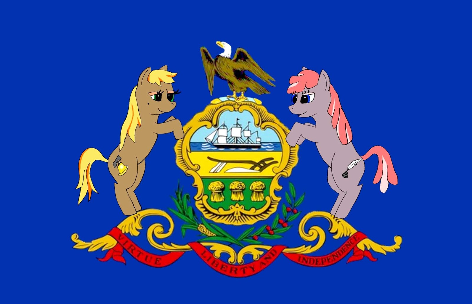
My Little Pony is an 80s reboot that has remade itself with a second life in the 20-tweens. It has a strong cult following. Out of all the state flags, the Pennsylvania State flag is the best suited to get a fun My Little Pony honor!
Official Flag of Pennsylvania
On the left is a brown pony, Liberty Bell, who represents the call of Providence. On the right is a periwinkle pony, Freedom Writer, whose words speak directly to the soul. These two little patriotic ponies appear when help is needed to set someone free from injustice, whether a physical or mental prison. Their primary passion for being, is, aiding people to follow their dreams, with one's heart as the compass, in the pursuit of happiness.
The divide between the North and South is enshrined with the border between Pennsylvania and Maryland. Long story short, slavery was an inherited institution found in all of the original 13 colonies. However, by 1860 the Union was divided into slave-states and free-soil states. Thus, the Mason-Dixon line became the de-facto dividing line between the North and South.
This flag is based upon the arms of Lord Calvert of Maryland and William Penn of Pennsylvania. Somewhat similar to the Maryland flag, however, the three white dots on the horizontal black stripe and two white field are the coat of arms of William Penn. While the black and yellow quarters represent Lord Calvert's arms. This flag is based upon the Crownstones that mark every 5th mile along the Pennsylvania-Maryland boarder. The north facing side has Penn's arms, while the south facing side has Calvert's arms. Note that every mile, excluding every fifth mile, it is marked with a P and M in the same manner for Pennsylvania and Maryland.
The Mason-Dixon line only goes so far, some historians have figured that it continued onto the Ohio River. When they do this, they are overlooking the fact that the Ohio river ain't a line. But if you really wanna' be a Mr. Smarty pants, the Mason-Dixon line technically isn't a line. Because, the world is curved; therefore it's an arc, so we could call it the Mason-Dixon Arc. No big deal, but what people are fixing at, is that it's the divide between slave and free soil. But people always overlook Delaware! Delaware was also a slave state back in 1860. Oddly the East-West Mason Dixon Arc of Longitude divides a slave state from the another slave state?
So no matter, this flag is to be flown along the divide of slave soil and free soil as it was in 1860. For the start, the flag can be flown anywhere along the border of Pennsylvania and Maryland. Then to the Ohio River, round' Pennsylvania. From where Ohio, Pennsylvania, and West Virginia meet, down the Ohio river, until it meets the Mississippi. Then upstream, northwards, up around Missouri, down along the western border of Arkansas. But then, we cut through Oklahoma, west, along the Arkansas River till it meets up with the Canadian River. Then around square hat of Texas.
The reason for cutting through Oklahoma's Canadian-Arkansas branch, is itsa' reminder of how divided the entire country was. We should never forget many of the Native American warriors in Oklahoma took the Confederate side, while just a minority took the Northern side. And yes, several battles took place in Oklahoma north and south of the Canadian River. Furthermore, the Canadian River is good a dividing point, because its name reminds us that we had two earlier wars against our own brethren to the far North, in 1812 and 1776.
Now back to the North-South, Calvert-Penn Flag route, once you go around Texas's square hat and hit 32 degrees north, you head due west along this line, or arc to be more scientifically accurate, of latitude. Reason being the first government to divide this western territory was the Confederate Government. By which, below the 32nd North, the Confederate state of Arizona was created.
Again, this a reminder of the deep divide politics can have, that another group of Americans were fixing to cut up New Mexico territory long different lines. The South even had a functional Confederate capital at Mesilla, C.S.A. Arizona, which is now officially a part of New Mexico. Finally the very west of the North-South/Calvert-Penn divide follows the modern west end of Arizona below 32 degrees north.
Oh yeah, finally, some consideration for Delaware. Since this flag represents the divide between free slave soil, it should be flown along the upper curve of Delaware from Marcus Hook, Pennsylvania to tri-state area of Pennsylvania, Delaware, and Maryland.
So we have a new flag dedicated to the fallen from the US Civil War. It's good to never forget the past, yet we must to live and cherish the now. Sometimes it's hard to put the shoe on the other foot. You can only guess how another is feeling, only God knows. Memorial Day was originally created to heal the wounds between the North and South, and this is another flag dedicated to that memory and bring a glimmer of honor on all sides.
A classic long forgotten game is Bionic Commando 1988 for the original Nintendo. An enemy flag of red, yellow, and black is in the distance. You can see it in the background here; it features a black falcon on a yellow-orange sun, upon a field of red. The bad guys are known as the BADDS. You might be thinking it's vaguely similar to the Nazi. And if you ever beat the game, then you might remember fighting Hitler in the end. If you beat him, then you would have seen his head explode in graphic 8-bit graphic glory.
The original game was known as ヒットラーの復活 - トップシークレット (Hitler's Resurrection - Top Secret) as it was known in Japan. However when it hit the American market, a name change was in order. Apparently American kids were deemed too soft to handle the Nazi imagery? Game play consisted as you controlling a red haired American hero, fighting the Badds/Nazis.
Here is a side by side intro scene of the Japanese and English versions. Notice the change in the flags. In the Japanese version the Neo-Nazi group had a flash lighting bolt symbol underneath the swastika.
Bionic Commando illustrates cultural censorship through flags and symbols in video games, which continues onto this day.
Nevertheless Bionic Commando is a memorable experience, with great game play, challenges, and is fun to play. The end fight scene is amazing action that gives the player total 8-bit satisfaction.

 Is that Mr. Seagull, Johnathan L.? With one of his disciples?