Translate

Tuesday, June 28, 2016

Cato Island Flag, Australia


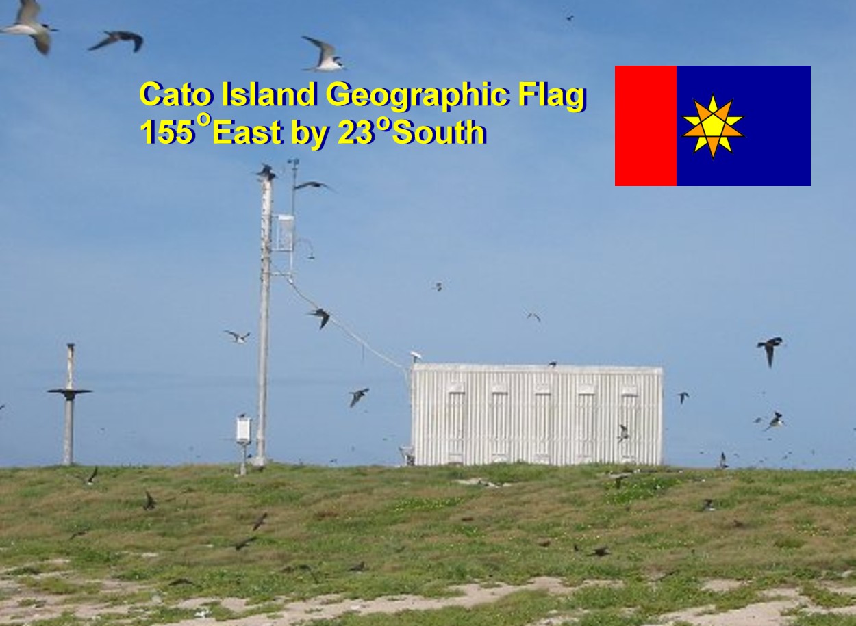
The Geographic flag for Cato Island, Australia has a background of red and blue, and the colours are coded to numbers.  In this case they mean 155.  Since five is repeated it forms a larger block.  The star in the center reveals the latitude of 23 Degrees South.

For these types of flag the colours are linked to numbers, based upon the order of the rainbow.  Red is 1; orange is 2, yellow, is 3, and blue is 5.  Thus the field reads as 155 Degrees East by 23 Degrees South. The front star pointing down indicates a Southern Parallel, while the yellow pentagon indicates the Eastern Hemisphere.


--------
Image Credit: Wikipedia
https://en.wikipedia.org/wiki/Cato_Reef#/media/File:Cato_Island_Station.jpg

Lo'ihi Seamount Flag


The Geographic Lo'ihi Seamount flag uses US patriotic colours of red, white, and blue with dash of black.  The colours are coded to numbers.  And the code is based upon the order a rainbow.  Red being the first colour, so it represents 1.  Blue as the fifth colour, it represents 5.  Also white represents zero, while black represents 8. 

Usually these types of flags are tribars, but since 155 Degrees West has two 5s, we have a blue field. 

In the center are two five pointed stars, which are coded to latitude.   They represent the number 18, for 18 Degrees North.  The dominant red star represents to tens column, while the background star represents the ones column.  Also the white pentagon indicates that this is the Western Hemisphere.  And finally the upward dominant star indicates that this is a Northern parallel. 

Also note this flag can be flown over the southern tip of Hawaii's King Island, since crosses this geographic panel.  

Lo'ihi is predicted to appear above the surface at earliest in the Year 9876 or at latest by Year 12,345.  By that time our species will have vanished like the dinosaurs due to cybernetic integration and genetic modifications.  But humans as we are today may be kept alive in 'zoos of the future' or traded like cattle to do menial and undesirable work.


-----------
Image Credit: http://www.nsf.gov/discoveries/disc_summ.jsp?cntn_id=132271

Monday, June 27, 2016

Geographic Salt Lake City Flag


The Geographic Salt Lake City flag has a field of red.  Usually Geographic flags are composed of tribars with each bar coded to color and number.  Since red is the first color of the rainbow it represents the number 1.

Since Salt Lake City sits at 111 Degrees West.  The field is completely red!  The central white pentagon also indicates that this is a western line of longitude.  Otherwise it would be yellow to indicate an eastern line of longitude.

The two stars show us the latitude, which is 40 degrees.  Since green is the 4th colour of the rainbow, the dominant star is green. 

---------
Image Credit: Wikipedia
https://upload.wikimedia.org/wikipedia/commons/4/46/Salt_Lake_City_montage_19_July_2011.jpg

Geographic Frankfort, Kentucky Flag


The Geographic Frankfort flag is a tribar of white, black, and green which represent the longitude.  The colours are coded to numbers, based upon the order of the rainbow.  Here white, black, and green represent the numbers 084, which is 84 Degrees West.  A Western longitude is indicated by the white pentagon in the center, otherwise if it is yellow then it is East. 

The central stars of yellow and black represent 38, which references 38 Degrees North.  Since the dominant yellow star is pointing up, it indicates the Northern Hemisphere.  Otherwise a downward dominant star would indicate the Southern Hemisphere.


Geographic Olympia, Washington State Flag


Perhaps the best place in the United States to watch the Olympics is at Olympia, Washington State - the state capitol.  There also Washington DC, but this is Washing CS.  The CS standing for Corner State, while the DC stands for District of Columbia.

The colours of Geographic flag are coded to numbers.  The order is based upon the order of a rainbow.  Red is 1, since it is the first colour; orange is 2 since it is the second colour; green is 4 since it is the fourth colour, and violet is 7; since it is the seventh colour. 

The field reads as 122 Degrees (Red-Orange-Orange), while the star reads as 47 Degrees (Green-Violet).  The central white pentagon indicates it is in the Western Hemisphere.  The dominant green star pointing upwards indicates that it is in the Northern Hemisphere.  Thus this flag reads as 122 Degrees West by 47 Degrees North, got it?


Sunday, June 26, 2016

Geographic Flag for Midway Atoll


The Midway Atoll Geographic flag has its colors coded to numbers.  The order of colors to numbers are based upon the rainbow.  Red is one, since it's the first color of the rainbow.  Orange is two, since it is the second color of the rainbow.  Purple is seven, since it is the seventh color of the rainbow. 

The field of one red to two purples makes it 177 Degrees.  The central white pentagon indicates that it is in the Western Hemisphere. 

The two 5 pointed stars indicate the latitude.  In this case it represent 28 Degrees North.  The dominant orange star, pointing up indicates 20 and the northern hemisphere since it is pointing up.  The lesser black star indicates 8.  When you add 20 to 8 you get 28 Degrees, which is that latitude of Midway.


Geographic Palmya Atoll Flag


The Geographic Palmyra Atoll flag is a tribar of red, indigo, and orange.  Each color is coded to a number that is reflective of longitude and latitude.  The code is based upon the rainbow.  Since red is the first color of the rainbow, it is number 1.  Orange is the second color of the rainbow, so it is number 2.  Finally indigo is the sixth color of the rainbow, thus it is assigned as 6.

The central stars related to latitude.  The dominant star is the 10s number while the background star is 1s number of latitude.


image credit: Wikipedia
https://en.wikipedia.org/wiki/Palmyra_Atoll#/media/File:Strawn_Island_at_Palmyra_Atoll_NWR_%285123999194%29.jpg