Translate

Sunday, June 26, 2016

Geographic Flag for the Panama Canal at: 79 Degrees West by 09 Degrees North

The flag for 79 Degrees West by 09 Degrees North includes the heart and much of the Panama Canal.


-------

Luanchuan, China Flag


 Luanchan just happens to lie on the 111 Meridian East.  Subsequently its geographic flag has a complete background of red.  In addition since it is on the 33 parallel north it gets an all upright latitude star. 

Note that red is coded to 1, since red is the first colour of the rainbow.  Likewise yellow is coded to 3, as it is the third colour of the rainbow. 

Using Latitude Longitude key here, you can fly this flag anywhere along this geographic space.


----------
image credit: http://lvyou.baidu.com/luanchuan/

Flag for Bawku, Ghana


Bawku lies at 0 Degrees West by 11 Degrees North.  This is the subsequent geographic colour coded flag.  It is a red star on white.  Since red is the first number of the rainbow, it represents the number one.  Likewise two red stars indicate 11. 


http://www.jhr.ca/blog/category/by-country/ghana-by-country/page/20/

Flag for the Senkaku or Diaoyu or Diaoyutai Islands


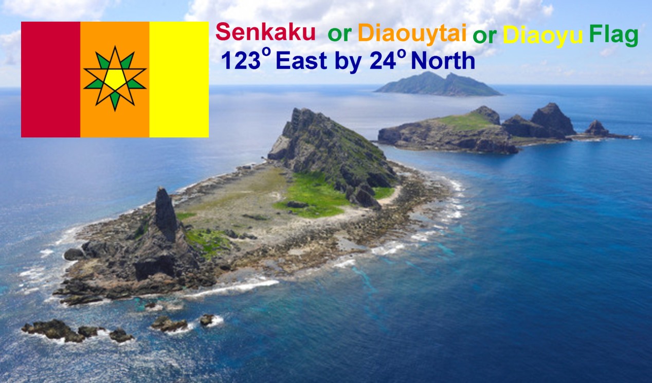
The geographic latitude and longitude flag for the Senkaku or Diaoyu or Diaoyutai Islands uses a tribar of red, orange, and yellow.  The three names of the islands are due to the three current claims on them by Japan, China, and Taiwan.

These colours are coded to numbers, which follow the established order of the official rainbow.  The first colour of the rainbow is red, so red is 1, then the second colour of the rainbow is orange, so orange is 2, and the third colour of the rainbow is yellow, so yellow is 3.  Thus the tribar represent the number 123, and these isles are at 123 Degrees East.  The Eastern Hemisphere is indicated by the central yellow pentagon, otherwise it would be white, which would indicate the Western Hemisphere.

The central stars represent numbers of latitude.  The dominant star is orange, coded to 2, while the lesser star is green, coded to 4 - since green is the fourth colour of the rainbow.  The dominant star also represents to 10s column of latitude, while the lesser star represents to 1s column of latitude.  Finally the dominant star is pointing upwards, indicates a northern line of latitude.

 --------------
 Image Credit:
http://www.bloomberg.com/photo/diaoyu-senkaku-islands-/390697.html


Flag for Gough Island


Gough Island is in the middle of the South Atlantic in the Western Hemisphere.  This is a geographic longitude and latitude flag coded to colours.  In this case since green is the 4th colour of the rainbow represents the number four.  White is represents zero, while pink represents nine.

This island is a part of the Tristan Da Cunha islands family.  It is virtual lonely life on an asteroid.


--------
image credit: Wikipedia
https://en.wikipedia.org/wiki/Gough_Island#/media/File:Gough_island_top_view.png

Saturday, June 25, 2016

Flag for the Lowest Point in the United States - Badwater Basin Geographic Points: 116 Degrees West by 36 Degrees North


Everyone in the USA above 5th grade knows that that tallest place in the USA is Mt. Denali, Alaska.  But when you ask for the lowest point, you usually get a shrug.  Here the lowest point is Badwater Basin, and its geographic flag has the colours red, indigo, white, and yellow. 

The order of colours is based upon the rainbow. 


Image Credit - Wikipedia:
https://en.wikipedia.org/wiki/Badwater_Basin#/media/File:Badwater_Basin_from_Dante%27s_View_Overlook.JPG

Flag for the Geographic Area Furthest from the Center of the Earth - Chimbarazo, Ecuador: 78 Degrees West by 01 Degrees South


The highest point on Earth is not Mt. Everest.  This is true when you factor in all aspects of air, sea, and land.  This measurement is based not upon sea level rising, but rather from the center of the Earth.  Bragging rights go to the nation named after the equator, Ecuador.  Or in a direct literal English translation - Equatorland.

The Belly Button of the Earth
This flag is a true scientific geographic grid flag.  The colours are coded to numbers, based upon the official order of the rainbow.  Since red is the 1st colour of the rainbow it is coded to 1.  Purple is the 7th colour of the rainbow, so it is coded to 7.  Since there are only seven colours in the official rainbow only seven numbers are coded to the rainbow.  Subsequently zero is coded to white and eight is coded to black.  Finally nine is coded pink.

Since this area is in the Southern Hemisphere, the dominant star is pointing downwards.  Likewise the central pentagon is white, which indicates the Western Hemisphere. 


image credit: Wikipedia

https://en.wikipedia.org/wiki/Chimborazo