Translate

Friday, July 1, 2016

Geographic Flag for Cites on the 10th Meridian East


The cities of the 10th Meridian East includes many nations and many cities.


 This flag reads 10 Degrees East by 3 Degrees North, which contains Edea, Cameroon.
 This flag read 10 Degrees East by 42 Degrees North, which contains Elba, Italy.
 This flag reads as 10 Degrees East by 12 Degrees North, which contains Nguru, Nigeria.
 This flag read 10 East by 36 Degrees North, which contains Tunis, Tunisia.
This flag read 10 Degrees East by 59 Degrees North, which contains Oslo, Norway.


---------------
For contrast, here are the flags for places on the 10th Meridian West, which still includes Europe and Africa.

 The Geographic flag for 10 Degrees West by 6 Degrees North contains Monrovia, Liberia.
 The Geographic flag for 10 Degrees West by 52 Degrees North contains Dingle Bay, Ireland.

Thursday, June 30, 2016

Geographic Flag of Diego Garcia


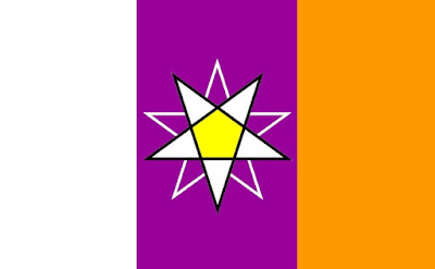
The Geographic Diego Garcia flag is a tribar of white, purple, and orange- which indicates a Longitude of 72 Degrees East.  The central stars of white and purple indicate a Latitude of 7 Degrees South. 

Diego Garcia is the Midway of the Indian Ocean, or rather, Midway is the Diego Garcia of the Pacific Ocean?

The colours are coded to numbers.  And the code is based upon the order of a rainbow.  Orange is 2, since it is the second colour.  Yellow is three, since it is the third colour and so on.


 Image Credit: Wikipedia
https://en.wikipedia.org/wiki/Diego_Garcia#/media/File:Diego_Garcia_Hernandia_Forest.png

Geographic Flag of Darwin, Australia


Darwin, Australia has the same tribar background as Kurume, Japan.  This is because they reside on the same meridian.  Both cities are a part of the 130th East.  What this means is that the majority of these inhabitants dream, sleep, and wake in unison.  It is especially for Australia whose culture puts great weight on the dream-time.  Likewise for Japan, where dreams are considered magical and special. 


Image Credits: Wikipedia
https://en.wikipedia.org/wiki/Darwin,_Northern_Territory#/media/File:City_landscape_of_Darwin,_Northern_Territory.jpg
https://upload.wikimedia.org/wikipedia/commons/4/46/Kurume_montage.png

Geographic Kurume Flag


The Geographic Kurume flag is a tribar of red, yellow, and white that is coded to the cities Longitude: 130 Degrees East.   In the center are two yellow stars that is coded to the Latitude: 33 Degrees North.  The central yellow pentagon indicates the Eastern Hemisphere, while the upward pointing dominant yellow star indicates the Northern Hemisphere.

Fun Fact!  Kurume is due North of Darwin. 


Geographic Beijing Flag


The Geographic Flag of Beijing has a field of red and indigo.  In the center is a yellow star dominant to a pink star. The background is coded to 116 Degrees East, while the stars show us 39 Degrees North. 


-----
Image Credit: Wikipedia
https://en.wikipedia.org/wiki/Beijing#/media/File:Hall_of_Supreme_Harmony,_Forbidden_City,_Beijing,_with_tourists_2.jpg

Geographic Rio de Janeiro Flag


The Geographic flag for Rio de Janeiro is a tribar of white, green, and yellow.  These colours are coded to zero, green, and yellow- which in turn are coded to numbers: 043.  The number 43 refers to Rio De Janeiro's Longitude at 43 Degrees West.  Likewise the two pointed orange stars refer to the number 22, since Rio's Latitude is 22 Degrees South.

The central white pentagon denotes that this is a Western line of Longitude.  Also the dominant upside down star denotes that this is a Southern Parallel.

The order of the colour to number is based upon the order of appearance in a rainbow.  Orange is 2, because it is the second colour of the rainbow.  Yellow is 3, since it is the third colour of a rainbow.  Green is 4, because it is the fourth colour of the rainbow.  Since there are only seven official colours in a rainbow, the numbers 8, 9, and 0 are coded to black, pink, and white; unless they appear in the pentagon or form the outline of the central stars of Latitude.

--------
 Image Credit: Wikipedia
https://upload.wikimedia.org/wikipedia/commons/9/94/Montagem_RJ.jpg


Wednesday, June 29, 2016

Geographic Flag for Cheyenne, Wyoming


The Geographic Flag for Cheyenne, Wyoming has a tribar of red, white, and green.  Each bar is coded to a number based upon the rainbow, which is reflective of Longitude: 104 Degrees West.  The stars in the center are coded to 41 Degrees North.  Red is the 1st colour and green is the 4th colour, while white is equal to zero.

The central white pentagon indicates a Western Line of Longitude, while the upward green star indicates a Northern Parallel.


------
Image Credit:
http://www.jiffyautoglass.com/cheyenne-wyoming.html